Facebook
Adams Soil and Water Conservation District
  • Home
  • Staff/Supervisors/Calendar
  • Rental/Sales
    • Equipment Rental
    • Tree Seedlings
    • Maps/Other Resources
  • Wildlife
    • Wildlife Specialist
    • Wildlife Conflicts
  • Beekeeper Info
  • Education
    • Newsletter
    • Adams Co. Fair
    • Boating Safety Education
    • Classroom
    • Cover Crop Field Day
    • Envirothon
    • Explore the Outdoors
    • Fishing Days
    • GE Day
    • Kindergarten Ag Day
    • 7th Grade Conservation Field Days
    • Scioto Brush Creek Day
    • Summer Science Camps
  • Our Watersheds
    • Ohio Brush Creek >
      • Ohio Brush Creek Sweep
      • A Paddler's Guide to Ohio Brush Creek
      • OBC Publication
    • Scioto Brush Creek >
      • Scioto Brush Creek Sweep
  • Our History
    • Formation of District
    • World Plowing Match
  • Annual Meeting
  • New Page

Ohio Brush Creek

Picture
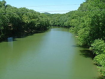
Ohio Brush Creek is a 59.9-mile-long (96.4 km) tributary of the Ohio River in southern Ohio in the United States.

Via the Ohio River, it is part of the watershed of the Mississippi River, draining an area of 435 square miles (1,130 km2).

According to the Geographic Names Information System, it has also been known historically as "Brush Creek," "Elk Creek," and "Little Scioto River".

Ohio Brush Creek rises in southeastern Highland County, and flows generally southwardly into Adams County, past the Serpent Mound, to its confluence at the Ohio River, about 4 miles (6 km) west of Rome.
           Adams Soil & Water Conservation District     807 NE Main St., #B  West Union, OH 45693     Phone: 937-544-1010